MONTRÉAL’S INTEGRATED APPROACH
Nancy Badeau
Biography:
Nancy Badeau has been the engineer heading the road safety team at Ville de Montréal since 2009. After working in road safety for over 30 years, she is getting ready to retire in April 2025. Nancy was also actively involved in various transportation associations throughout her career, including the Transportation Association of Canada and the Association québécoise des transports.
Summary
This article briefly explains the integrated approach Montréal has taken to reduce traffic speed and improve road safety. The 2008 Transportation Plan marked a turning point, containing a strategy to promote public and active transportation, which included setting a 40 km/h limit on local streets. Additional measures were implemented, such as automated speed enforcement systems and active mobility development projects.
In 2019, Montréal adopted its first Vision Zero Action Plan, aiming for zero deaths and serious injuries by 2040, by taking measures such as reducing the speed limit to 30 km/h on residential streets and improving safety around schools. The 2022–2024 Action Plan continued this integration with tools to design streets that encourage appropriate speeds.
The Vision Zero interactive website gives an overview of the safety measures taken, with a focus on speed management measures. The 2050 Land Use and Mobility Plan aims to reduce motorized travel and promote sustainable modes of transportation, in keeping with the safe system approach and Montréal’s commitment to Vision Zero.
Historical background and 2008 Transportation Plan
For several decades now, Ville de Montréal has been actively implementing road safety measures intended to reduce speed and improve residents’ quality of life. These initiatives are part of a comprehensive, integrated approach to reduce transportation-related nuisances and promote safe, sustainable travel. This approach enables the City to focus on a range of actions and measures that, together, contribute to reducing the risk of serious and fatal crashes, making it safer for everyone to get around.
The implementation of speed reduction measures dates back to 1992, when the City introduced a 30 km/h speed limit around schools and parks (1), with the exception of arterial roads. Over the years, it carried out speed reduction projects in certain residential areas. It also occasionally carried out traffic calming projects on streets with a speeding issue.
The 2008 Transportation Plan marked a turning point in Ville de Montréal’s approach to transportation and road safety. The plan adopted an overall strategy aiming to increase the modal shares of public transportation and reduce automobile use (1). A total of 21 development programs were proposed to support this strategy, including one aiming to improve transportation safety. The transportation safety program contained numerous actions, including creating calmer-traffic neighbourhoods, adapting street layouts to encourage active transportation, changing behaviours and educating and raising awareness among users.
The introduction of a 40 km/h speed limit on all of Montréal’s local residential streets was one of the key safety measures in the 2008 Transportation Plan. This project clearly demonstrated the new direction being taken to promote active and public transportation and improve quality of life in neighbourhoods by providing safer infrastructure. Setting a 40 km/h limit made it possible to justify and implement other traffic calming measures to reduce speed and the number of vehicles in neighbourhoods. Figure 1 shows the result of rolling out this speed limit project on the City’s territory in 2011.
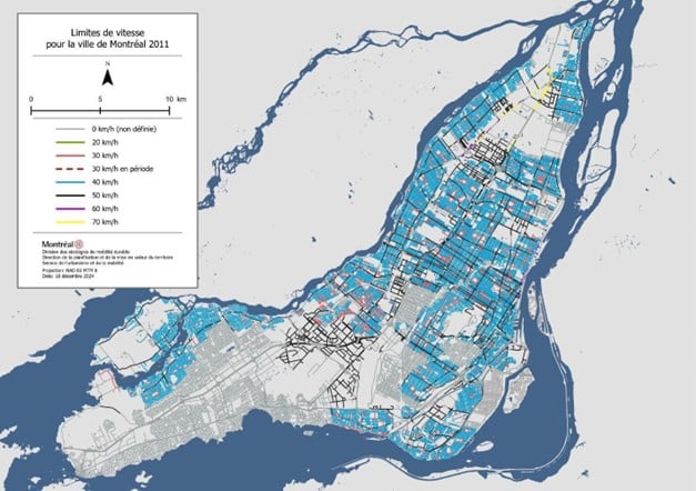
Figure 1: Speed Limits in Montréal in 2011 Following the Implementation of a 40 km/h Speed Limit
Several other measures were taken in the years that followed, including:
- Implementation of automated speed enforcement systems in collaboration with the provincial government;
- Development of a concept for calmer-traffic neighbourhoods and a guide for designing these (2);
- Implementation of projects to redevelop streets and make them safer, fostering active and shared mobility.
Redevelopment projects to encourage active transportation all contributed, directly or indirectly, to reducing speed. Such projects included installing bicycle lanes, widening sidewalks, building curb extensions and implementing pedestrian and shared streets. The aim was to reallocate the street space, reducing vehicular capacity by allocating it to other activities and modes of transportation. These new uses enlivened the side of the street, encouraging drivers to slow down.
In 2019, Montréal adopted its first Vision Zero Action Plan, whose focus was building a solid foundation for working better together and setting a target of zero deaths and serious injuries by 2040 (3). This plan put human life first, and recognized the importance of acting on all the components of the transportation system in consultation with all partners. Several speed reduction measures were proposed, including:
- Continuing to lower the speed limit from 40 km/h to 30 km/h on local residential streets and reducing the speed limit from 50 km/h to 40 km/h on some arterial roads with a considerable number of vulnerable users.
- Continuing to implement speed-lowering measures, especially around parks and in school zones.
- Implementing a school street safety program, which made it possible to finance the rolling out of traffic calming measures.
- Optimizing the Police Department’s use of mobile photo radar.
It was also during this first Action Plan that the first express bike network (EBN) routes were created. Setting up this bike network significantly changed the allocation of the street space, reducing vehicle capacity and therefore speed.
The second Vision Zero Action Plan (2022–2024) consolidated the integration of the Vision Zero approach in development practices and in urban planning (4). One action worth mentioning is the enhancement of the online Répertoire des pratiques d’aménagement de la rue (directory of street design practices) (in French only) (5). This directory is used to disseminate the guides and guidelines for street design developed by Ville de Montréal’s land use and mobility department. The aim is to standardize the practices throughout the territory and ensure compliance with the City’s high-level sustainable mobility, road safety, universal accessibility and climate change resilience policies (4).
One of the most recent data sheets that marks an important change in practice is the Outil de conception — Largeur de voies (in French only) (6). This tool explains the importance of determining lane width, especially in urban areas, to ensure speeds of 50 km/h or less. The approach involves starting from a standard lane width of three metres and justifying its increase. The width is determined by:
- The lane’s position on the roadway;
- The street’s traffic characteristics (including desired speed, presence and frequency of certain types of vehicles);
- The horizontal alignment characteristics.
This fact sheet will help redevelopment project designers to design streets that encourage appropriate speeds and take into account the fragility of the human body.
Overview of the rollout of certain safety measures
In addition to providing various human crash statistics, Ville de Montréal’s Vision Zero interactive website also lists the safety measures implemented by the boroughs in the “Mesures de sécurisation” tab. The measures fall into four categories:
- Street crossing: Measures in this category include curb extensions, raised intersections and pedestrian islands.
- Bicycle traffic: Measures include bollards, buffer zones and islands separating bicycle lanes and vehicle lanes.
- Speed management: Measures include radar speed signs and speed bumps.
- Traffic management: Measures mainly included changes in street directionality.
The category with the highest number of measures implemented is speed management.
To date, boroughs have reported installing either speed bumps or radar speed signs on 3,125 stretches of street. Some boroughs have systematically installed speed bumps, while others have installed them on streets around schools and parks, and in sensitive areas. The central boroughs, which have the highest population and activity density, have the highest rollout of traffic calming measures. For example, Figure 2 shows street segments with speed bumps in the Côte-des-Neiges–Notre-Dame-de-Grâce borough. This is one of Montréal’s most populous boroughs. The measure has been implemented on more than 40% of these local residential streets.
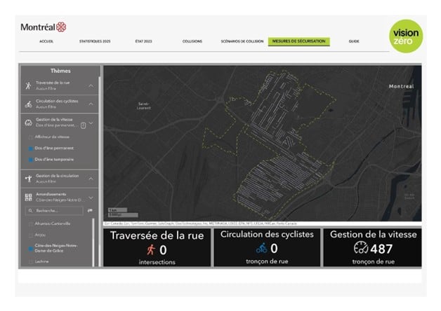
Figure 2: Excerpt from the Vision Zero Interactive Website Illustrating the Extent of Streets with Speed Bumps in the Côte-des-Neiges–Notre-Dame-de-Grace Borough
Figure 3 shows that by 2024, more than half (55%) of Montréal’s road network would have a 30 km/h speed limit. That means that only 18% of streets (arterial roads and streets in industrial areas) would still have a 50 km/h speed limit. It is worth noting that some major roads, especially in the middle of the island, are already set at 40 km/h. On several of these, the limit was lowered following a major redesign of the roadway to incorporate a separate bicycle lane, including the St-Denis EBN.
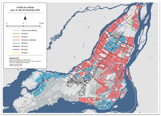
Figure 3: Speed Limits in Montréal in 2024
The third Vision Zero Action Plan (2025–2027) (7) sets out plans to continue efforts to reallocate streets and redesign the street space to develop and encourage active and public modes of transportation and make them safer, in view of reaching the target of zero deaths and zero serious injuries by 2040. The priorities are:
- Fairly reallocate the street space.
- Reduce speeds.
- Make arterial and collector roads safer.
- Make the streets used by the most vulnerable safer.
- Develop a Vision Zero culture.
In the past, speed reduction efforts have focused on local streets. They will now focus on the arterial and collector road network, where 90% of crashes in Montréal resulting in serious injury or death still occur. All together, the 45 actions listed in this new plan will help achieve a sustainable mobility network with appropriate speeds to keep the risk of serious injury at a tolerable level. However, some measures will be more coercive, notably a wider rollout of automated speed enforcement systems in collaboration with the Ministère des Transports et de la Mobilité durable, which remains responsible for the next rollout of these systems.
These systems will be especially useful in school zones, which are located on the arterial road network and where the limit will soon be lowered to 30 km/h, while waiting for street redevelopment measures to be implemented.
Despite the initial coherence of these actions, the rollout order of several measures was not without its issues. There have been times, for example, when the street’s development did not result in appropriate speeds, or speeds consistent with the posted speed limit or with usage. However, efforts to develop various tools and integrate them into Ville de Montréal’s strategic plans ensure that the measures will be rolled out to reach Vision Zero. That is what is planned in the 2050 Land Use and Mobility Plan.
Future – Vision of the 2050 Land Use and Mobility Plan (8)
In 2024, Ville de Montréal unveiled its 2050 Draft Land Use and Mobility Plan for consultation. This plan is the master document that sets the vision for the future of the municipal territory and the guidelines for its spatial and physical organization. The vision is of a green, just and resilient city. The solutions used to roll out a sustainable mobility network to optimize land use will have to make it possible to:
- Reduce the number and distance of individual motorized trips by significantly increasing the sustainable mobility offer.
- Shift all potential travel to active and collective modes of transportation.
- Improve the performance of the remaining motorized trips by focusing on sharing, transport pooling, electrifying transportation and making it energy-efficient.
The City’s integrated planning is consistent with the safe system approach. It makes it possible to go beyond implementing simple speed reduction measures to address a specific speeding issue. The aim is to reduce risks at the source by acting on all components of the travel system. That is what will guide Montréal’s choices.
References
- Ville de Montréal, 2008 Transportation Plan: Réinventer Montréal. 2009, p. 220.
- Ville de Montréal, Guide d'aménagement durable des rues de Montréal - Fascicule 1 Quartiers verts. 2012 (the approach described in this guide is outdated, but it shows the direction the City was taking).
- Ville de Montréal (2019), 2019–2021 Vision Zero Deaths and Serious Injuries Action Plan, Des assises solides pour mieux travailler ensemble.
- Ville de Montréal (2022), 2022–2024 Vision Zero Deaths and Serious Injuries Action Plan.
- Ville de Montréal, Taken from the Répertoire des pratiques d'aménagement de la rue (consulted March 2025)
- Ville de Montréal, Outil de conception — Largeur de voies. Consulted on the website in March 2025.
- Ville de Montréal (2025), 2025–2027 Vision Zero Deaths and Serious Injuries Action Plan, Des déplacements sécuritaires pour toutes et tous. Document in the process of being approved, p. 74.
- Ville de Montréal (2024), 2050 Land Use and Mobility Plan