Applying the Right Transportation Paradigm to Increase Safety and More: One Approach to Increasing Transportation Safety in Cities
By Ian Lockwood, Professional Engineer
Livable Transportation Engineer
Toole Design Group
Bio: Ian Lockwood is a national leader in sustainable transportation policy and urban design. He has worked on various projects to make communities more walkable, bikeable, and transit-friendly, and has a Loeb Fellowship from Harvard University.
Abstract: The following article recalls an experience of compromised road safety from the perspective of a cyclist. This experience inspired a journey towards making a difference in pedestrian and cyclist safety via better transportation planning and design. After offering a brief history of the rise of the automobile and city design, this article highlights key features of the traditional approach, which prioritizes street design for short trips, placemaking, accommodating different user groups, and slower speeds, to name a few. Such efforts require the support across various sectors because ensuring the safety of all road users truly takes a village.
A Magnifying Moment of Compromised Safety
In the Spring of 1976, I saw the most beautiful road bike in the window of the bike shop around the corner from my house. With the goal of buying that bike, I got my first summer job. I worked at a midway booth at a carnival, where customers paid to throw baseballs at empty beer bottles, placed in pairs on narrow shelves at the back of the booth. They got three throws and, if they could break two bottles with one throw, then they won a large stuffed toy frog. That summer I made enough money to buy my dream bike. Throughout high school, my bike and I did everything together... we explored the city, went to school, camped, and eventually competed in triathlons. I loved my bike.
I was heading home one sunny Saturday afternoon on a two-lane street that led to a bridge that I needed to cross to get to my house. There were no bike lanes back then. Through no fault of my own, I was hit by a bus. I learned the hard way that getting hit by a bus was “like getting hit by a bus.” It was amazing how massive a bus seemed when my face was momentarily squished against its steel body and all I could see in every direction was metal. Then, in an instant, I felt like a cookie crumb getting flicked off a countertop. As I flew through the air. I narrowly missed a wooden telephone pole. As I passed the pole (in slow motion in my mind), I noticed how it resembled a cactus because it was covered in rusty finishing nails from decades of notices being nailed to it. I continued my flight path over the landscaped strip and sidewalk, and landed in an empty asphalt parking lot. I rolled and came to a stop on my back... I lay still... I did not notice that the asphalt was hot as I stared up at the desert-blue sky. My bike landed on the steps of the building next to the parking lot. The bus driver did not stop, leaving me for dead. My bike and I were never quite the same afterwards. In sum, the crash left impressions on us both.
My bike needed extensive repairs and new parts. After my recovery, I continued to ride it throughout university and to my first transportation engineering job. Interestingly, during my undergraduate and graduate studies, the transportation professors never mentioned the word “bicycle,” not once, even though my bike was usually leaning on the back wall of the lecture hall. It was clear that bike planning and design were not important, academically, at the time.
However, through a bike organization that I had joined, I learned that my crash was hardly a one-off; thousands of other cyclists and pedestrians were being hit, injured, or killed in cities all over North America every year. I also learned that some cities in Europe were building infrastructure for cycling, which increased safety and promoted more active transportation. Yet, in North America, thousands of people were being hit, nothing was being done, and wonderful, healthy, and fundamental modes of transportation were being systemically disadvantaged. In grad school, I studied traffic calming and took courses related to city planning and design. At my first transportation engineering firm, I was committed to making a difference in pedestrian and cyclist safety via better transportation planning and design.
Since then, 38 years have passed and I’m still on that mission. There is plenty more to do and, fortunately, I’m not alone. There are many hundreds of kindred spirits who share the same mission. They are in the public sector, private sector, non-profit sectors, professional organizations, academia, and the general population. I’ve learned that there is a myriad of ways to increase safety for all street users (e.g., motorists, cyclists, transit users, walkers, people with disabilities, older adults, children, etc.). My approach to our shared mission is practiced by numerous people. It is aligned with the history of ground transportation and city-making and is shaped by community values.
Every day, people are hit by motorists in cities across the continent. Each person who was hit, injured or killed is far more than a data point. They are/were someone’s sibling, friend, child, neighbor, spouse, workmate, etc. We all need to be part of the generation that ends this problem.
A Short History on Ground Transportation in Cities Prior to the 1930s
The human species evolved into its current form about 300,000 years ago. Over that time, people naturally gathered in different types and sizes of groupings and settlements. Cities, as we think of them today, began evolving about 10,000 years ago and, consequently, streets and blocks were formed then too. The fundamental mode of transportation was walking. Thousands of years later, horses were domesticated and people could ride them or be pulled behind them. Roughly 400 years ago, transit was invented, which involved large carriages pulled by horses. Then, the bicycle was invented. Shortly afterwards, as iron technology improved and steel rails were feasible, trolleys and trains were developed and became effective modes of transportation in cities.
During this entire time, the pedestrian was the common denominator for transportation and city design because walking was needed to access everything, including the trolley lines and train stations. With transit technology, cities expanded across greater distances via transit-oriented developments, such as trolley suburbs. Around the year 1900, the “horseless carriage” was invented. The popularity of automobiles increased dramatically during the 1930s, 1940s, and 1950s. Prior to the popularity of automobiles, there were about 400 generations of people who incrementally evolved cities into a condition that I call, “Peek Urbanism,” which occurred sometime during the 1930s.
The Purpose of Cities and Streets
Why were cities invented in the first place? The purpose of cities was (and still is) to bring people and resources together for the purposes of efficient and effective exchange (i.e., the exchange of labor, education, innovation, goods, culture, entertainment, governance, employment, social contact, security, health care, and a variety of other services). From a transportation perspective, cities exist to reduce long-distance trip-making (i.e., create proximities so that people can facilitate exchange via short trips or transit). Land use patterns, densities, street networks, distribution systems, and transit, had all evolved to foster exchange.
Up until Peek Urbanism, streets were multi-purpose public spaces that generally operated at low speeds (i.e., 5-11 km/h or 3-7 mph), which is how fast your horse walked, regardless of the type of street. Streets provided venues for commerce, socializing, celebration, communication, travel, access, deliveries, identity, legibility, and place. There were no ubiquitous traffic signals, speed limit signs, crosswalks, etc. Pedestrians could cross a street wherever they wanted safely and comfortably. Every street, in every city, across North America was a “shared space” in which navigation between the various user groups was done through inter-human communication, which is feasible at slow speeds.
The Largest and Fastest Disruptor in the Evolution of Cities
When the car was invented, it represented a huge leap in technological innovation. For the first time in history, individuals could travel at high speeds in a personal vehicle in a city. However, cities, streets, social norms, transit systems, markets, and distribution systems had not been designed for high-speed individual travel. For a period of about 400 generations, before the invention of the car, city-making evolved slowly via trial-and-error, incremental adjustments, planning changes, and design innovations, with the goal of increasing access, human interaction, and exchange. Slow speeds were the norm.
A “disruptor” is something new that causes a radical change in an existing industry, market, or place. It was not the invention of the car that disrupted cities and caused the current problems with safety, sprawl, large carbon footprints, car-dependency, etc. The disruptor was how the car was accommodated. The disruptor was a focused combination of untested policies, funding mechanisms, and methods to quickly retrofit traditionally designed cities into cities for cars and high design speeds.
The Failed Experiment
Post-World War II (WWII), a colossal experiment was imposed on traditional cities to accommodate high speed travel by car. The costly experiment was supported at every level of government with the creation of powerful policies, specialized transportation organizations, huge funding priorities, and costly and untested physical retrofits in cities. These experiments were fueled by the modernist movement’s ideas, which were initiated between about 1910 and 1930. The modernists painted a compelling picture of futuristic cities in which travel by car was quick and convenient. It was equated to freedom and progress. Modernists invented a functional classification system of roads, pro-speed metrics, new technical language, and new rules that altered the roles of streets to prioritize the throughput, speeds, and access for motorists. Even the slowest street type, local streets, was assigned a default speed of 50 km/h or 30 mph, which was 500% faster than the pre-car speeds. Navigation, via inter-human communication between the various user groups, was impossible with motorists travelling at such high speeds, so the non-motorists were required to use the edges of streets, except at intersections. Traffic control devices were invented as a substitute communication system. The idea that motorists could get from A to B quicker, rather than slower, was so compelling that the experiment moved forward with gusto for three generations.
Modernists invented new theories to justify higher speeds for motorists. Likely, their most damaging theory had to do with the value of land. For almost 10,000 years the traditional paradigm indicated that the value of land was a function of the land’s proximity to the center of the city. The closer the land was to the center, the more valuable the land. The modernists dismissed the traditional perspective and popularized their new theory: the value of land was a function of travel time to the center. By speeding up the streets for motorists in the city, the 5-minute, 10-minute, 15-minute… “travel-time contours” would spread out and include more land, thus increasing the value of the land.
This theory informed many of the conventional transportation performance metrics that exist today, such as levels of service for motorists, and a myriad of conventional metrics related to reducing travel times for motorists.
These conventional values are also foundational to conventional “traffic demand forecast models,” which are used to advance conventional practices. Sadly, the modernists’ theory was wrong. The land along the streets, that were sped up, devalued and the streets became barriers. The value was exported, from the center of the city to the edges of the city and resulted in suburban sprawl. Interestingly, encouraging longer trips and high speeds for motorists to overcome proximity violated the fundamental purpose of cities, which is to shorten trip lengths and reward proximity. No wonder serious problems occurred quickly.
If the modernists’ theories about accommodating cars at higher speeds were good for cities over the last three generations, then cities would have evolved to become better. So, in hindsight, let’s ask some questions about cities getting better, after trillions of dollars were spent on experimenting on cities with higher speeds and car-dependency. Are our streets and cities more comfortable for pedestrians and cyclists now, compared to pre-car days? Are our cities more walkable and more connected? Is the environment better off? Are our cities more beautiful? Have cities become better places? Is transit more effective and mode splits better? Are our cities more resource-efficient now in terms of land consumption, energy consumption, and raw material use? Is community health better? Are houses more affordable? Do all populations enjoy equitable mobility? Do our children walk and cycle to school in greater numbers? Are cities more fiscally sustainable than they were previously? Are the maintenance costs for infrastructure more affordable? Do people who walk, cycle, and use transit feel safer and more dignified than they did previously? I would suggest that the answer to a lot of these questions is a resounding “No.” As a result of these massive experiments, it seems clear that cities and their populations in North America suffered to various degrees based on how thoroughly they retrofitted their cities towards motordom (i.e., a society, dominated by automobiles with car-centric infrastructure and lifestyles, that is perpetuated by an alliance of industries, lobbyists, and government entities).
The Modernists’ Ways
The modernists’ created an incredibly effective, multifaceted, process to advance motordom. In North America, the modernists’ simplistic pro-speed and pro-automobile values and ideas infiltrated every level of government. Supportive laws, funding streams, and departments were created. Supportive transportation policies, automobile parking regulations, and zoning changes were made. They had the support of powerful industries such as the automobile manufacturers, oil companies, rubber companies, road builders, and sprawl developers, all of whom were profit-motivated. Universities were provided with funding to create supportive research, technical books of standards were written and required on every transportation engineer’s bookshelf, and a common set of technical terms was created with pro-speed and pro-automobile biases (e.g., improvement versus widening; delay versus changes in travel-time; city road versus city street; accident versus collision; congestion versus excessive car volumes; mass transit versus public transit; traffic demand versus automobile use; etc.)
The design of new, suburban, street networks became the purview of developers instead of cities. It was in their self-interest to not connect their development’s streets with their neighboring development’s streets. Consequently, the connected street networks of traditionally designed cities ceased to expand into the post WWII suburbs. Consequently, the newer suburbs tend to rely on a sparse network of formerly farm-to-market roads, which concentrates long-distance travel by car on just a few roads, exacerbating the barrier effects on those roads and making complete streets less feasible. Despite all that, support for the modernists’ ways was, and continues to be, secured and reinforced by a steady stream of lifestyle-oriented messaging that is pro-speed, pro-automobile, and pro-suburbs in TV commercials, magazines, and sponsorships. Simple ideas such as, “Do you want to get to work faster rather than slower?” are continually repeated to overpower the more nuanced sensibilities of traditional city planning and design.
The modernists’ planning and design schemes were founded on untested and flawed principles that cannot succeed at a city-scale over time. With three generations of testing, they failed and, unfortunately, a lot of damage was done. Pause for a minute and let “three generations” sink in… that represents less than 1% of the history of cities. In the timeline of cities, these enormously disruptive and untested changes were implemented with blistering speed. That was made possible by the modernists’ creating separate entities, led by specialized experts, to handle the various aspects of city-making. One group dealt with zoning, another dealt with parks, another dealt with transportation. A different group, at a higher level of government, dealt with highway building. Other entities dealt with schools, economic development, transit, etc. Today, we call these “silos.” The idea was to expedite change because each group could move forward independently with minimal coordination. The modernists, who spurn complexity, dismissed the fact that all these topics greatly affect one another. Three generations of observing the experiment show that the lack of coordination and integration resulted in numerous bad outcomes.
Many people now live in low-density, car-oriented, and resource-consumptive suburbs. They are car-dependent and their communities are difficult (but not impossible) to retrofit. The cities’ once ubiquitous transit systems have been removed or diminished. Long distances now exist between people’s daily and weekly needs and their suburban homes. The passage of time and the thoroughness of the shift from a traditional paradigm to a conventional paradigm has resulted in a professional and political amnesia in North America about how great cities are made domestically. Conventionality is unfortunately considered normal, but its dominance is beginning to lessen. Though it still has plenty of inertia, the conventional paradigm will eventually run its course in North America and be replaced with a paradigm that employs more sustainable and time-tested principles.
Some Fundamentals of the Traditional Approach
In my work, I recognize two key patterns: i) the cities that persist with the modernists’ conventional paradigm and the related performance metrics have the least sustainable, comfortable, safe, and beautiful outcomes; and ii) the cities that have learned from the failed experiment and are adopting more of the pre-car, traditional, paradigm by rewarding slow speeds, proximities, transit, denser and more mixed land uses, are the better cities. They are safer, more comfortable, and more economically vibrant.
The following list summarizes the approach that I use to increase safety and achieve other desirable outcomes on streets and in cities. I recognize that it is going to take me and many other people many years, or even decades, to make damaged or underperforming cities inherently better, in general, through the application of traditional values and, specifically, by planning and designing streets and cities to simultaneously:
- reward short trips
- accommodate many different user groups
- emphasize placemaking
- achieve slow speeds for motorists through design
- increase access
- reduce vehicle-kilometers/miles traveled in total and per capita
- provide modal choices through pedestrian, bicycle, and transit infrastructure
- nurture businesses, increase social interaction, and add character
- integrate better land use planning and transportation planning
- employ the policies and practices that model cities, domestically and abroad, are using to cure themselves of car-dependency and related negative outcomes.
From a safety perspective, these changes reduce exposure, vulnerability, and hazards (i.e., they reduce the three contributing factors to risk).
I am confident that this approach will result in better cities from a variety of perspectives, including better identity, better community health, more transportation options, less energy consumption, more economic vibrancy, and increased safety. I feel this way because I see these patterns expressed in real cities, domestically and abroad, and through my own projects.
The approach I use is two-fold. First, I work to plant traditional seeds (i.e., traditional ideas) in conventional places through talks, papers, and other outreach. Those places may not be ready for reform or change now, but they will likely be ready over time. Second, I do traditional planning and design work in cities that are ready (or almost ready) to move past the conventional approach and do something that actually has the potential to achieve the communities’ desired outcomes. The idea is to create model projects and places around North America where traditional values prevail over conventional values. Then, people from other places will find out about these model places, visit, and then want to do similar things in their own cities.
One cannot just, with a snap of the fingers, undo three generations of conventional changes. Traditionalists, like me, do not have the luxury of simplistic sound bites to convince people to do more of the same thing and hope for better outcomes, such as, “Hey, if we just keep adding more car lanes to your streets and highways, then congestion for motorists should be solved, and everything will be fine.”
Capacity Building: It Takes a Village
Fixing a conventionally damaged city is a process that can be summed up as “traditional city-making.” It is best initiated through “capacity building” (i.e., empowerment through educational outreach) within the whole community, ranging from decision-makers to city staff, to non-profit organizations, and to the general public. The goal is to achieve an informed consensus for a direction for the place or city. The process begins with gathering community values through community outreach, which are used to create a community vision. Then a set of principles are developed to shape the policies, programs, plans, and projects so that, as each program or project is implemented, the city moves another step closer to achieving its vision.
Nobody ever does any of the above alone. To build a better city, it takes a village: on the consulting side, it takes a diverse planning and design team and an enlightened client; on the city staff side, it takes all the departments to dismantle their silos and work together; and on the public side, it takes awareness-building and involvement. If you are a technical expert in transportation planning and design, then that is laudable; however, the community members are experts in their values, histories, contexts, and aspirations. You must collaborate with the community to get the best results. At a leadership level, it takes trust in the process, championing the vision, and the empowerment of the staff. For everyone involved, it requires collaboration, effective communication, and feedback loops so that everyone stays and feels involved.
Personal Experiences: West Palm Beach
Again, no individual is ever responsible for great projects or great city-wide outcomes... it always takes a team. I have had the good fortune to have been on many wonderful teams, sometimes as the team leader and sometimes as a team player. Below, I describe an experience that began three decades ago. It aligns with the traditional approach that was discussed previously, taught me a lot, and influenced my work ever since. Every subsequent project, over my career, reinforces my conviction that this traditional approach achieves multiple good outcomes simultaneously.
From 1996 to 2001, I led the City of West Palm Beach’s Transportation Division. The Mayor had completed an extensive community outreach effort which resulted in a clear vision for what the city ought to be like in the future. The vision was starkly different to what the city was like at the time. It was a rather impoverished, unkept, abandoned, crime-ridden, and disrespected place. The City had only $7,000 in reserves; we were effectively broke. A documentary about drug abuse, called “Crack America” was filmed in the downtown and was nominated for an Academy Award for Best Documentary Feature in 1989. Half of the buildings in the downtown were torn down due to dilapidation or to make room for surface parking lots.
The Mayor empowered her staff to work together, with the city's meager resources, to achieve the vision. Her strategy was that a compelling vision, accompanied by a feasible plan, strong leadership, and a “tax increment finance district” would attract private investment and people back to downtown. That is exactly what happened. During a period of about five years, billions of dollars of private investment and thousands of people came into the city, despite the previous decades of disinvestment and decay. The city’s tax base increased, city pride increased, and the city's reputation improved greatly. The City’s vision of becoming a nice medium-sized city was achieved. The city has kept on a positive trajectory ever since.
From a transportation perspective, my predecessors had altered the arterial streets to reward long automobile trips and fast speeds. That strategy damaged the city by creating barriers, making the streets uncomfortable, ugly, and dangerous. The conventional street designs also hurt businesses, suppressed active transportation, and exported value to the suburbs, leaving behind a relatively empty city with vacant buildings, disinvestment, crime, and a sense of unease. By systematically changing the streets, in keeping with the communities’ traditional values, we were able to create more inclusive, beautiful, safer, more comfortable, and more vibrant streets, which combined with the new private development resulted in a better city.
Interestingly, the term “road diet” was coined on one of those arterial projects. Throughout that process, conventional transportation engineers from Palm Beach County and the Florida DOT obstructed the policy-reforms and physical changes that the City was trying to make. At that time, conventional transportation thinking dominated. Today, the County and the Florida DOT have changed their ways significantly, which makes it easier for them and other cities to follow the West Palm Beach model.
One of the obstructions was a requirement imposed on the City by the County and Florida DOT. It required the City to use a model to prove that the transportation changes would “work.” We had two models, Copenhagen and Vancouver, Canada. The County and DOT clarified that they meant a “traffic demand forecast model.” By “work” they meant that there "would be a “reasonable” level of service for motorists during peak times. We clarified that, by “model,” we meant real model cities that had similar problems as West Palm Beach and used traditional solutions to achieve a vision that aligned with our vision. By “work” we meant that we’d get a higher-performing city in terms of quality of life, vibrancy, etc. The fight over what “model” meant, almost went to court until the Secretary of the Florida DOT backed out. He found out that the City was fully prepared to go to court and prove that the cumulative errors in the traffic demand forecast model created results that were statistically as good as a guess. We were putting their model on trial. We also knew that we could prove that our model cities improved themselves by doing good land use planning and good transportation planning. We felt that a judge would relate to the results from real cities and not to an error-riddled, digital facsimile, from a black box.
During the implementation of our vision, the word got out, and transportation delegations, from cities across the country, visited West Palm Beach to study what we were doing. They were inspired by: i) there being a domestic model for traditional practices; ii) that we rejected the conventional paradigm; iii) that Carmageddon did not occur as the County and Florida DOT had predicted; and iv) that the city was getting better from many perspectives. I suspect that these delegations would have benefitted even more had the modelling case gone to court, throwing shade on using conventional traffic modelling for unconventional planning purposes. Rest assured that we routinely use transportation modelling at Toole Design Group, but we understand that the models are only tools, they are not oracles, and they are certainly not a substitute for good judgment.
I have similar stories from Winter Garden FL, Chattanooga TN, South Bend IN, Sulphur Springs TX, and many more places. None of these projects were easy. The struggles can be summarized as proxy fights between which paradigm should prevail: the conventional paradigm or the traditional paradigm. For brevity purposes, at the end of this paper, I’ll let some “before” and “after” pictures convey a thousand words each to tell the stories.
Final Thoughts
The approach that I use to increase safety is to make safety an intrinsic part of programs, policies, plans, and projects. I resonate with this approach because it helps cities and places on several fronts simultaneously. When you look at the following “before” and “after” pictures, focusing just on safety would not have delivered what was needed. The unsafe conditions were only one problem, but there were lots of problems. A more holistic project was needed in each case to make a better place and city. Again, there are numerous other circumstances, and numerous other ways to increase safety and many approaches are needed.
I encourage everybody involved in city-making and transportation projects to reject the conventional paradigm, dispel the modernist myths, and help the public and every organization who is involved understand the patterns. I encourage the professionals to collaborate with their broader communities and stakeholders. In that way, the cities and streets will approach their potential more fully and more quickly, while achieving better outcomes, including increased safety.
As people who share the same mission of increased safety, let’s strive to cut the number of crashes, fatalities, and injuries by half, and then half again, and so on, until our streets and cities are truly safe, comfortable, vibrant, and wonderful places to be. Then, perhaps, future youth will look at cool bicycles in the windows of their local bike shops, eventually buy them, and ride their bikes happily around their cities for years... free-range kids like I was in the 60s and 70s, but riding without the risk of getting hit by a motorist, especially one driving a bus.
“Before” and “After” Pictures
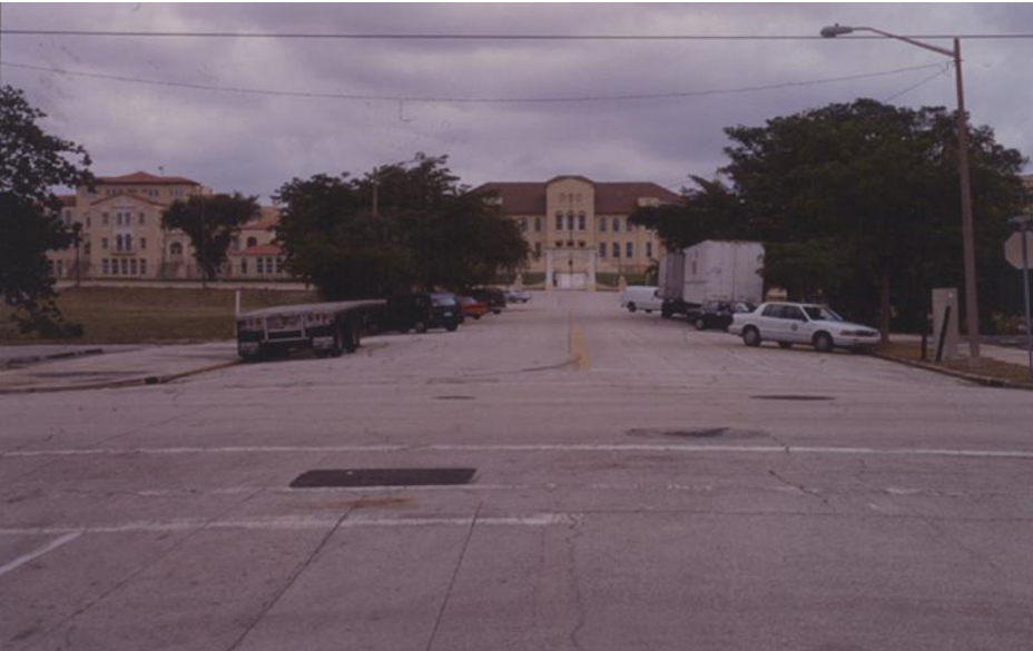
West Palm Beach FL, Hibiscus Street, “Before” Picture
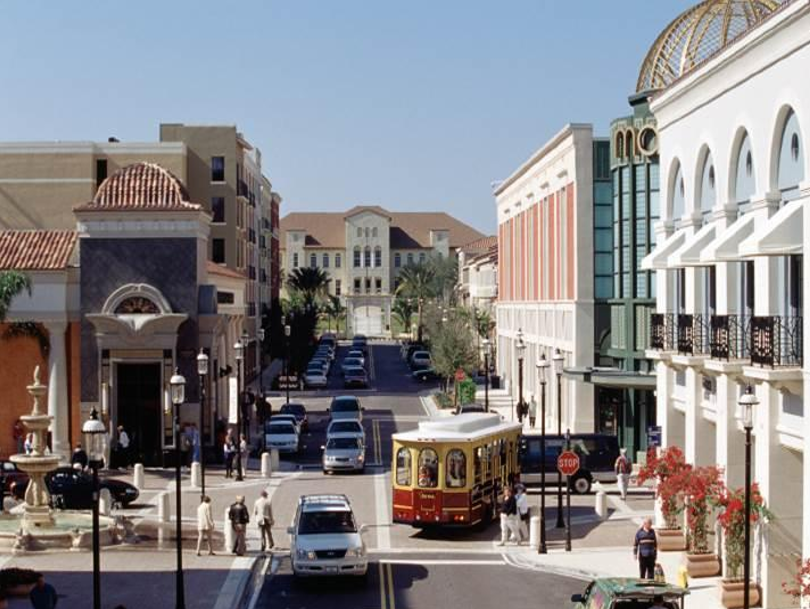
West Palm Beach FL, Hibiscus Street, “After” Picture